Beyond Florida: The Expanding Geography of Hurricane Risk Most Homeowners Aren't Preparing For
Beyond Florida: Hurricane Helene and the Expanding Geography of Risk That Most Homeowners Aren't Preparing For
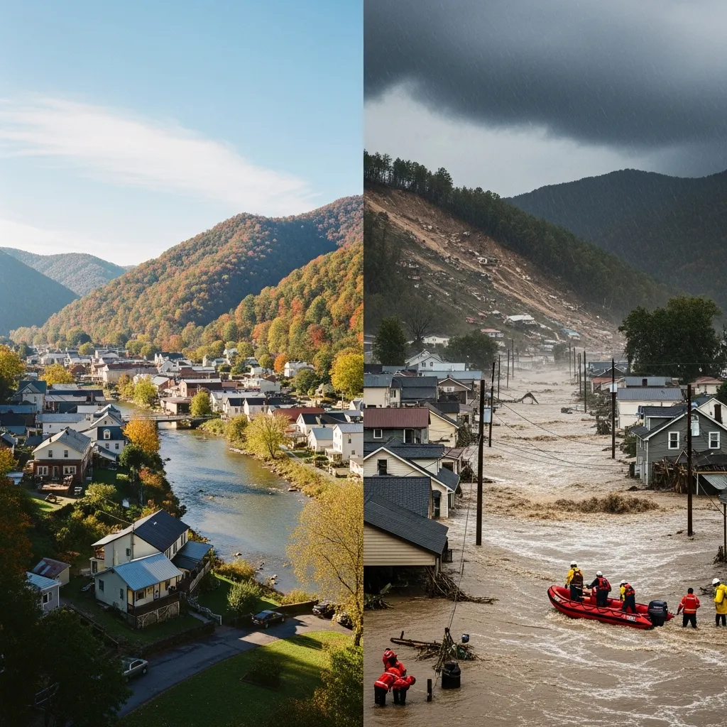
The City in the Mountains
Asheville, North Carolina, sits in the Blue Ridge Mountains, roughly 300
miles from the nearest coastline. Its elevation is 2,134 feet above sea
level. It is surrounded by the Appalachian range, sheltered by geography
that has shaped the city's identity for more than a century. Asheville
is a place people move to for craft breweries, mountain trails, and the
Biltmore Estate. It is not a place anyone associated with hurricanes.
In the years leading up to September 2024, media outlets had begun
calling Asheville a "climate haven" --- a destination for Americans
relocating away from coastal flooding, extreme heat, and yes, hurricane
risk. People were moving to the mountains specifically because they
believed the mountains would protect them from the weather patterns
threatening the coasts.
On September 26, 2024, Hurricane Helene made landfall in Florida's Big
Bend region as a Category 4 storm with 140-mph winds. It crossed into
Georgia still carrying Category 2 intensity. Then, instead of
dissipating as most landfalling hurricanes do, Helene drove north into
the southern Appalachians carrying an extraordinary volume of moisture.
What happened next was close to a worst-case meteorological scenario for
a region that had never planned for one.
Over a three-day period, the mountains around Asheville received
rainfall that NOAA's National Water Center classified as a
1-in-1,000-year event --- meaning there was less than a 0.1 percent
chance of it occurring in any given year. The weather station at Busick,
North Carolina, recorded 30.78 inches of rain. Mount Mitchell State Park
recorded 24.41 inches. Asheville's airport recorded 13.98 inches in
three days. The moisture-laden air from the Gulf of Mexico hit the
mountain slopes and was forced upward, condensing and releasing its
water in volumes the terrain could not absorb.
Rivers that normally trickled through mountain valleys became walls of
water. The French Broad River in Asheville exceeded the previous flood
record --- set during the Great Flood of 1916 --- by more than a foot
and a half. Nearly 2,000 landslides were documented by the U.S.
Geological Survey. All roads in western North Carolina were closed to
non-emergency travel. The North Carolina Department of Transportation
could not even access some communities for days.
The death toll across six states exceeded 250 people, making Helene the
third-deadliest hurricane of the modern era behind Maria and Katrina.
More than half of those deaths occurred in North Carolina --- in the
mountains, hundreds of miles from the coast where people associate
hurricane danger. NOAA's National Centers for Environmental Information
estimated the total damage at \$78.7 billion, making Helene the
seventh-costliest U.S. tropical cyclone since 1980. FEMA reported that
only 0.8 percent of households in disaster-declared North Carolina
counties held flood insurance.
Asheville was not supposed to be a hurricane story. It became one of the
worst hurricane stories in American history.
Can Hurricanes Affect Homes Far From the Coast?
Yes. Hurricane Helene made landfall in coastal Florida in September 2024
and carried catastrophic destruction more than 500 miles inland to the
Appalachian Mountains of North Carolina. Asheville, at an elevation of
2,134 feet and roughly 300 miles from the nearest coast, experienced
record-breaking flooding that exceeded the previous 108-year-old record.
NOAA classified the rainfall as a 1-in-1,000-year event. Hurricanes
damage communities far from the coast through inland flooding from
extreme rainfall, wind damage that persists hundreds of miles from
landfall, river overflow from saturated watersheds, and landslides
triggered by rainfall on mountainous terrain. Since 1980, FEMA has
issued hurricane-related disaster declarations in 23 states, many of
them far from any coastline.
Four Regions Most Homeowners Never Consider
If you live outside Florida, you have probably spent your life filtering
out hurricane content. It did not feel relevant. The storms hit the
coasts, the news covered the destruction, and you changed the channel
because it was someone else's problem. That assumption was
understandable. It was also wrong. The following regional profiles cover
the four areas beyond Florida where hurricane damage has been
catastrophic, repeated, and largely underprepared for.
The Gulf Coast Beyond Florida: Louisiana, Mississippi, Alabama, and Texas
The Gulf Coast from Louisiana to Texas has absorbed some of the most
devastating hurricanes in American history, and the damage patterns
continue to accelerate. Hurricane Katrina made landfall in Mississippi
in 2005 with a storm surge that reached 28 feet, killed more than 1,800
people, and caused an estimated \$190 billion in damage adjusted for
inflation. It remains the benchmark against which all American hurricane
disasters are measured.
But the Gulf Coast's hurricane history did not end with Katrina.
Hurricane Harvey stalled over Houston in 2017, dropping more than 60
inches of rain over four days and flooding neighborhoods that had never
flooded before. Hurricane Laura struck southwestern Louisiana in 2020 as
a Category 4 storm, and Hurricane Ida followed in 2021 with 150-mph
winds that destroyed the electrical grid across much of southeastern
Louisiana. In 2024, Hurricane Beryl made landfall in Texas as a Category
1 storm and still killed more than 30 people, largely through inland
flooding and power outages that lasted weeks in extreme heat.
The Gulf Coast corridor from Lake Charles, Louisiana, to Galveston,
Texas, has been struck by a major hurricane in five of the last eight
years. Homeowners in these communities live in a hurricane zone whether
they frame it that way or not.
The Carolinas: North Carolina and South Carolina
The Carolinas sit in a geographic position that exposes them to storms
approaching from the Gulf, storms curving northward along the Atlantic
seaboard, and --- as Helene demonstrated --- storms that carry their
moisture deep inland over the Appalachian range.
Hurricane Florence stalled over eastern North Carolina in 2018, dropping
more than 30 inches of rain and producing catastrophic river flooding
that did not crest for days after the storm passed. Entire towns were
submerged. Hurricane Matthew in 2016 caused similar river flooding
across eastern North Carolina, with some communities experiencing their
worst floods since records began. Hurricane Hugo struck South Carolina
in 1989 as a Category 4 storm with 135-mph winds and remains the
strongest hurricane on record to hit that state.
The lesson of Helene is that Carolina hurricane risk extends far beyond
the coastal counties where attention is typically focused. Western North
Carolina --- a region of mountain communities, small towns, and terrain
that funnels and accelerates floodwater --- was devastated by a storm
that made landfall 500 miles away. The building codes in many of those
communities did not account for hurricane-force conditions because the
communities never considered themselves hurricane-vulnerable.
The Northeast: New York, New Jersey, Connecticut, and Beyond
The northeastern United States does not think of itself as hurricane
country. That perception survived until Hurricane Sandy in 2012 --- and
was shattered again by the remnants of Hurricane Ida in 2021.
Sandy affected the entire East Coast from Florida to Maine, as well as
states as far inland as West Virginia, Ohio, and Indiana. In New York
and New Jersey, the storm surge reached historic levels, flooding subway
systems, destroying thousands of homes, and causing tens of billions in
damages. FEMA's response to Sandy led directly to the Sandy Recovery
Improvement Act of 2013, which restructured federal disaster recovery
procedures.
Nine years later, the remnants of Hurricane Ida produced catastrophic
flooding across the urban Northeast. Basement apartments in New York
City flooded so rapidly that eleven people drowned in their homes. Flash
flooding overwhelmed infrastructure in New Jersey, Pennsylvania, and
Connecticut that was not designed for the rainfall volumes that
post-tropical systems now deliver to the region.
Northeastern homeowners face a particular vulnerability: aging
infrastructure, dense construction, and building codes that were written
for nor'easters rather than tropical systems. The storms reaching these
communities are not weakening the way historical models predicted.
Inland Communities: Mountains, River Valleys, and Corridors
Helene was the most dramatic example of inland hurricane destruction,
but it was not the first. Western North Carolina has a documented
history of catastrophic flooding from weakened hurricanes and tropical
remnants, including the Great Flood of 1916 and significant flooding
from the remnants of Hurricane Frances in 2004.
The pattern extends across the Appalachian corridor. River communities
in Tennessee, Virginia, and West Virginia are vulnerable to the same
mechanism: tropical moisture pushed against mountain terrain, producing
rainfall that overwhelms watersheds never engineered for those volumes.
During Helene, emergency declarations were issued for seven states ---
Florida, Alabama, Georgia, South Carolina, North Carolina, Tennessee,
and Virginia. The storm's impacts extended across an area roughly 500
miles long.
The common thread across all four regions is the same. Homeowners who
never identified as living in a hurricane zone experienced
hurricane-level destruction. Their communities were underprepared, their
insurance was inadequate, and their homes lacked the physical protection
that might have reduced the damage.
Which States Are at Risk for Hurricane Damage?
At least 23 states have received FEMA hurricane-related disaster
declarations since 1980. Eighteen states currently allow
percentage-based hurricane deductibles in insurance policies, including
Alabama, Connecticut, Delaware, Florida, Georgia, Hawaii, Louisiana,
Maine, Maryland, Massachusetts, Mississippi, New Jersey, New York, North
Carolina, Rhode Island, South Carolina, Texas, and Virginia. Beyond
these, inland states including Tennessee, West Virginia, Ohio,
Pennsylvania, and Indiana have experienced significant damage from
hurricanes and their remnants. Hurricane Helene produced emergency
declarations in seven states in 2024. Hurricane Sandy affected states
from Florida to Maine and as far inland as Ohio. Hurricane Ida's
remnants caused fatal flooding in New York, New Jersey, Pennsylvania,
and Connecticut. Any state within the Gulf or Atlantic hurricane
corridor --- and any state downstream of the Appalachian mountain range
--- faces measurable hurricane risk.
Why the Geography of Risk Is Getting Larger
The expansion of hurricane damage beyond traditional coastal zones is
not random. It is driven by documented physical trends that climate
scientists have been measuring for decades. These are not political
statements. They are measured observations from NOAA, NASA, and
peer-reviewed research institutions.
Warmer ocean temperatures. Sea surface temperatures in the Atlantic
and Gulf of Mexico have been running at or near record levels. A
peer-reviewed study published in Environmental Research: Climate found
that human-caused ocean warming boosted the intensity of all eleven
Atlantic hurricanes in 2024, increasing maximum sustained wind speeds by
9 to 28 mph. Thirty of 38 Atlantic hurricanes studied between 2019 and
2023 reached a higher category on the Saffir-Simpson Scale than they
would have without warming oceans. Warmer water provides more energy to
storms and more moisture to fuel rainfall.
Storms maintaining intensity farther inland. Helene entered Georgia
still carrying Category 2 winds --- an unusual degree of intensity for a
storm that had already crossed an entire state. The massive size of the
storm, fueled by exceptionally warm Gulf waters, allowed it to maintain
its moisture and energy far deeper into the continent than typical
landfalling hurricanes. As NOAA noted in its 2025 hurricane season
outlook, the impacts of hurricanes can reach far beyond coastal
communities, citing both Helene and Tropical Storm Debby as recent
examples.
Extreme rainfall and rapid intensification. Models estimate that
warming has increased hurricane extreme hourly rainfall rates by
approximately 11 percent, because each degree Celsius of warming allows
the atmosphere to hold roughly 7 percent more moisture. This translates
to more rain falling over shorter periods, overwhelming drainage systems
and saturating soils that then produce flooding and landslides. The
number of storms undergoing rapid intensification --- gaining 35 mph or
more of wind speed in 24 hours --- has increased significantly. Most of
the costliest U.S. hurricanes since 1980 underwent rapid intensification
before landfall.
The practical implication for homeowners is straightforward: the
geographic boundary of meaningful hurricane risk is larger than it was a
generation ago, and it is still expanding.
Why Are Hurricanes Getting Worse?
Hurricanes are intensifying due to several measured physical trends.
Ocean temperatures have been running at record or near-record levels
since 2023, providing more energy and moisture for storm development. A
2024 peer-reviewed study found that human-caused ocean warming boosted
maximum wind speeds for 80 percent of Atlantic hurricanes from 2019 to
2023 by an average of 18 mph. Warmer atmospheres hold approximately 7
percent more moisture per degree Celsius of warming, increasing rainfall
rates by an estimated 11 percent during hurricane events. Storms are
undergoing rapid intensification more frequently, with extreme
intensification events increasing significantly from 1990 to 2021.
Additionally, rising sea levels --- roughly 8 inches since the late 19th
century --- allow storm surge to travel farther inland. The combination
of warmer seas, more moisture, faster intensification, and higher sea
levels means hurricanes are producing more damage over wider geographic
areas than in previous decades.
The Question That Follows
If you found your region in the profiles above, the geography of your
risk has just changed. Not because the risk is new --- in most cases,
the storms have been hitting these regions for years. What changed is
your awareness that the risk applies to you.
That awareness creates a question. If you are reconsidering whether your
home sits in a hurricane risk zone, there is another assumption worth
examining: that your insurance will handle whatever happens. Most
homeowners in the communities devastated by Helene, Harvey, Ida, and
Sandy believed they were adequately insured. Many discovered otherwise
only when they filed a claim.
In North Carolina, only 0.8 percent of households in Helene's
disaster-declared counties held flood insurance. In Houston after
Harvey, homeowners in neighborhoods that had never flooded discovered
their standard policies excluded the water damage that destroyed their
homes. In New York after Ida's remnants, renters and homeowners in
basement apartments had no coverage for the flooding that proved fatal.
The next article in this series examines exactly what your insurance
policy covers in a hurricane --- and the specific, structural gaps that
can leave you exposed to tens of thousands of dollars in uninsured
losses. It is the financial reality that most homeowners discover too
late, and it is the reason that physical protection of your home is not
just an engineering decision but a financial one.